Middle East Geography Quiz
True / False
True / False
Middle East Geography Mix Ups That Cost Points (Borders, Seas, Capitals)
Most misses in Middle East geography come from treating the region as a single block. Intermediate level questions often hinge on subregions, waterway connectors, and modern border history after 1918.
Overgeneralizing what counts as the “Middle East”
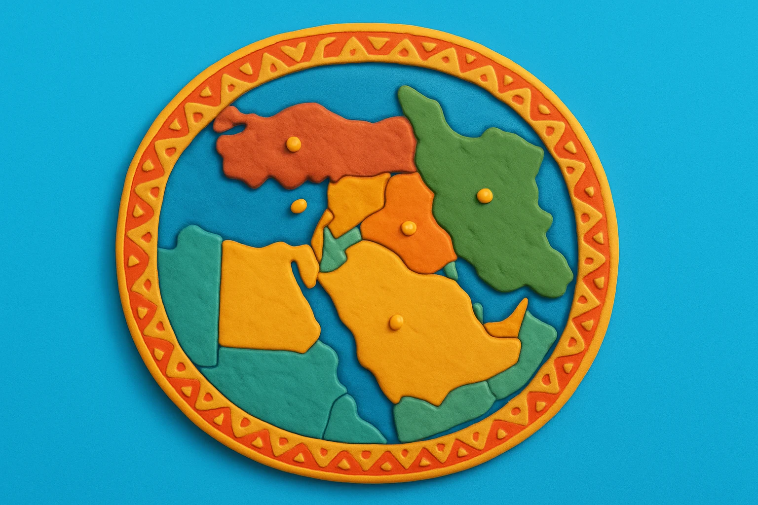
- Mistake: Assuming every map includes the same set of countries. Fix: Use a core set (Egypt, the Levant, Iraq, the Arabian Peninsula, Iran, Turkey), then watch for the quiz’s map extent and labels.
- Mistake: Mixing “Middle East” with “MENA” automatically. Fix: Treat North Africa west of Egypt as a separate convention unless the map explicitly includes it.
Sea and strait name swaps
- Mistake: Confusing the Persian Gulf with the Gulf of Oman. Fix: Memorize the sequence: Persian Gulf, Strait of Hormuz, then Gulf of Oman into the Arabian Sea.
- Mistake: Putting Bab el Mandeb near the Suez. Fix: Bab el Mandeb is the southern gate of the Red Sea at Yemen and the Horn of Africa.
Capital and “big city” traps
- Mistake: Picking Dubai as the UAE capital. Fix: UAE capital is Abu Dhabi, while Dubai is the best known emirate city.
- Mistake: Using Istanbul as Turkey’s capital. Fix: Turkey’s capital is Ankara, while Istanbul anchors the Bosporus.
Misplacing physical regions and their edges
- Mistake: Treating Mesopotamia as a synonym for all of Iraq. Fix: Use it for the Tigris Euphrates lowlands, not for Iraq’s northern uplands.
- Mistake: Blurring the Iranian Plateau with the Arabian Peninsula. Fix: Use the Persian Gulf as your divider, then place the Zagros along Iran’s western spine.
Ignoring map conventions for disputed and divided spaces
- Mistake: Answering from a political opinion instead of the map legend. Fix: Read boundary styling (solid, dashed, shaded) and follow the cartographer’s conventions exactly.
Five Map Anchors for Middle East Regional Geography
- Break the region into five repeatable subregions
Most location questions become easier if you sort features into Anatolia, the Levant, Mesopotamia, the Iranian Plateau, and the Arabian Peninsula. This reduces random memorization and helps you infer neighbors, climates, and river directions from first principles.
Action:Before you start, sketch the five subregions from memory and place one landmark in each (Ankara, Beirut, Baghdad, Tehran, Riyadh). - Memorize the four chokepoints that connect three continents
The Suez Canal and Sinai corridor link the Mediterranean and Red Sea. The Strait of Hormuz controls access between the Persian Gulf and Gulf of Oman. Bab el Mandeb gates the Red Sea to the Gulf of Aden. The Bosporus and Dardanelles link the Black Sea to the Aegean via the Sea of Marmara.
Action:Practice tracing one continuous route on a blank map: Black Sea to Aegean, Mediterranean to Red Sea, Persian Gulf to Arabian Sea. - Rivers start in uplands, not in deserts
The Tigris and Euphrates rise in the highlands of eastern Turkey and flow toward the Persian Gulf. The Jordan River system is tied to the Levantine highlands and the Dead Sea basin. Settlement patterns on many maps make sense only if you track headwaters, tributaries, and lowland corridors.
Action:On a blank map, draw arrows for Tigris, Euphrates, and Jordan, then label the main lowlands they define. - Use climate and relief belts to check your answers
A Mediterranean coastal strip contrasts with interior steppe and major deserts, especially across the Arabian Peninsula. Mountain belts such as the Taurus and Zagros create rain shadow patterns and natural corridors that often align with transport and population density on thematic maps.
Action:After each question, do a quick plausibility check: coastal, upland, or desert, then adjust if the feature feels misplaced. - Treat borders as modern artifacts that vary by map purpose
Many political borders were formalized in the twentieth century after the collapse of the Ottoman Empire, then revised through conflict, treaties, and administration. Reference maps may also depict special cases with different symbology, including autonomous regions and territories under separate administration.
Action:When a question involves borders or territories, answer from the map legend and boundary styling, not from memory alone.
Verified Atlases and Map Portals for Middle East Geography
Use these references to confirm spellings, borders as mapped, and physical geography labels across multiple map styles.
- UN Geospatial, Middle East map download: Official UN base map with standard political labeling and boundary conventions.
- Perry Castañeda Library Map Collection, Middle East: University curated map index with political, physical, and historical map scans for comparison practice.
- Library of Congress, “Middle East” map item: A stable historical map record useful for seeing older border and place name conventions.
- USGS, Tectonic Map of the Arabian Peninsula: Physical geography context for mountain belts, plate boundaries, and structural regions.
- FAO AQUASTAT, Irrigation in the Middle East region in figures: Water geography reference with river basin and resource context for arid and semi arid zones.
Middle East Geography Quiz FAQ: Definitions, Place Names, and Disputed Areas
These answers reflect how most reference maps and atlases label the Middle East for geography study and quiz contexts.
Which countries are usually included in “the Middle East” on quiz maps?
Most quiz maps use a core centered on Western Asia plus Egypt: Turkey, Iran, Iraq, the Levant (Syria, Lebanon, Israel, Jordan, plus the West Bank and Gaza on many maps), and the Arabian Peninsula states. Some maps extend the frame to include Cyprus, the Caucasus, or North Africa beyond Egypt. Always anchor your answer to the map extent and legend.
What is the difference between the Levant, Mesopotamia, and the Fertile Crescent?
The Levant is the Eastern Mediterranean coastal and near inland zone, commonly centered on modern Syria, Lebanon, Israel, Palestine, and Jordan. Mesopotamia refers to the Tigris and Euphrates lowlands, focused on much of modern Iraq and parts of Syria and southeastern Turkey. The Fertile Crescent is a broader arc that links Levantine and Mesopotamian agricultural zones in older historical geography writing.
Persian Gulf or Arabian Gulf, which name should I use in answers?
Answer with the term used on the map or in the question stem. Many international reference maps label it as the Persian Gulf, while some regional and political contexts use Arabian Gulf. If the quiz asks about the strait, focus on the fixed connector name, Strait of Hormuz.
How should I handle disputed or non sovereign areas like the West Bank, Gaza, and Kurdish regions?
Follow map symbology. Many educational maps show the West Bank and Gaza as distinct areas, often with special boundary styles or labels. Kurdish populated regions are usually shown as a cultural or ethnolinguistic area across parts of Turkey, Iraq, Iran, and Syria, not as a single sovereign state. If the prompt asks for a country, do not answer with a cultural region.
What are the most common capital city traps in the Gulf and eastern Mediterranean?
UAE capital is Abu Dhabi, not Dubai. Turkey’s capital is Ankara, not Istanbul. Israel’s government seat and map labeling vary by source, so treat the quiz map as the authority for that item. If capitals are a recurring weak spot, pair practice here with the World Capital Cities Knowledge Check.
Which waterways should I know cold for Middle East map questions?
Be able to place the Mediterranean, Red Sea, Black Sea, Caspian Sea, Persian Gulf, Gulf of Oman, and Arabian Sea. Then memorize the connectors that quizzes love to ask about: Suez Canal, Strait of Hormuz, Bab el Mandeb, Bosporus, and Dardanelles. For physical feature vocabulary practice, the map reading skills also carry over to US Rivers, Mountains, and Landmark Trivia.
Want more quizzes like this? Explore the full QuizWiz workplace quiz library.